Mapping our changing coastline


Congress is looking to boost an ongoing project to aggregate U.S. coastal mapping data.
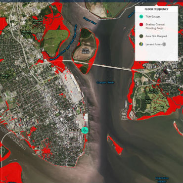
A detail of a NOAA map showing rising sea levels around Charleston, S.C.
Amid a lethal hurricane season that has battered American cities from Houston to San Juan, a bipartisan group in Congress is continuing a push for legislation supporting a federal initiative to better leverage data to help describe and protect America's coastlines.
Dubbed the Digital Coast Act, the sponsors say the legislation would build "coastal resiliency" by strengthening an already-existing federal web-based project, Digital Coast, that was launched thanks to an innovative partnership between the National Oceanic and Atmospheric Administration and hundreds of organizations including private industry, local agencies, non-governmental organizations and nonprofits.
A digital ecosystem including atlases, almanacs, reference libraries, archives and shipping data is the result. Digital Coast is curated by NOAA, which calls the project a unique "one-stop shop" for all things coastal, from Ohio's riverbanks to Alaska's Bering Sea.
With half of the American population living and working near a coast, this initiative is critical for coastal safety and also for the nation's future economy and infrastructure, according to Rep. Dutch Ruppersberger (D-Md.) who wants the project to be backed up by a statutory mandate. Co-sponsors include Rep. Don Young (R-Alaska) and fellow Democrats Rep. Charlie Crist (D-Fla.) and Elizabeth Esty (D-Conn.).
"Geospatial mapping information can be complicated, expensive to collect, and difficult to use without in-house expertise," according to a statement released by the bill's sponsors.
It's all about data visualization, ease of use and access, said Nicholas Schmidt, chief of the Science and Geospatial Division for NOAA's Office for Coastal Management, who explained that the agency "designed the website" for users to better "visualize data and not have to worry about the technology behind it." He said that the integrity of data was "critical" and that NOAA's job was to serve as curator of the aggregated coastal data and help transform data "into powerful information."
The collaborative nature of the project is key to its success, according to NOAA, which noted that "most users don't have the time or desire to search an array of vast sites to gather relevant data bit by bit. Compiling data sets from other agencies with one point of access saves users valuable time."
The Digital Coast project pulls together materials from multiple jurisdictions -- another reason for federal support, Ruppersberger said.
Previous attempts to pass the bill came up short, as coastal issues had not been perceived as a priority by many people, Ruppersberger explained. But this year, the tide of public opinion may have turned. "Because of the hurricanes, I think maybe people are more aware of why we need data," he said.
Hurricane mapping over the years is one interactive feature on the Digital Coast site at present. Additional context is provided that includes evacuation routes and an archive of post-hurricane recovery efforts. A Sea Level Rise Viewer allows users to visualize coastal flooding scenarios.
Making knowledge transparent, according to Schmidt, should "enable better decision-making" both about ocean- and river-related issues and the land-based economic and community issues that are influenced by coastal factors such as storm surges.
The proposed Digital Coast Act would supply NOAA with the funds needed to ensure the Digital Coast project's future growth -- from increasing the availability of core datasets and geospatial mapping to further extending educational programs. The Senate passed a similar bill in May under unanimous consent.
NEXT STORY: State Department CIO to Retire